
A deep depression over the Bay of Bengal has brought heavy rainfall to parts of Andhra Pradesh and Odisha, leading to the evacuation of at least 3,500 people and prompting authorities to issue red and orange alerts for several districts.

One person was killed in a landslide caused by heavy rains in Vijayawada city but no other casualties have been reported from elsewhere so far, according to sources in the State Disaster Management Authority.

The southwest monsoon has withdrawn from India, while the northeast monsoon has commenced in southern regions, bringing a wet spell. This year's southwest monsoon saw a rainfall deficit, largely attributed to the strengthening El Nino conditions, which are expected to persist until February 2027 and could become the strongest since 1950.

Cyclone Hudhud pounded the coastal districts of Andhra Pradesh and Odisha with heavy rain and winds of almost 200 kmph on Sunday killing four people and left a trail of destruction with Vishakapatnam where the very severe storm made landfall the worst hit.

The Odisha government has initiated evacuations and deployed disaster response teams in anticipation of Cyclone 'Montha', which is expected to impact the southern and coastal regions of the state.

Severe cyclonic storm 'Montha' has begun making landfall off the Andhra Pradesh coast, with the process expected to continue for the next three to four hours. The storm is expected to cross the coast between Machilipatnam and Kalingapatnam, near Kakinada, with wind speeds of 90-100 kmph.

Meanwhile, the Indian National Centre for Ocean Information Services (INCOIS) issued high sea waves, up to 4.7 metres high, warning across several coastal districts.

'We should expect extreme heat, extreme rains, floods, landslides and maybe cyclones. Not just this year, in the coming year as well.'

"Montha over westcentral Bay of Bengal moved north-northwestwards with a speed of 17 kmph during the past six hours and lay centred at 2.30 am on October 28 over the same region about 230 km south-southeast of Machilipatnam (and) 310 km south-southeast of Kakinada," said the Met Department in a release.
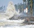
Cyclone Ditwah is moving towards the Tamil Nadu coast, bringing the threat of heavy rainfall. The state government is reviewing preparedness measures, and a red alert has been issued for southern and delta districts.

India's marine product exports facing rough weather from punitive US tariffs are expected to get a big boost following the reduction of 26 per cent tariff as part of the India-EU Free Trade Agreement (FTA), but concerns over non-tariff barriers, which are a dominant aspect of marine trade to the EU, still remain.

Cyclone Ditwah exits Sri Lanka after causing widespread destruction and over 120 deaths, heading towards the Indian coast. Heavy rains and high winds are expected to continue.

The early onset of the southwest monsoon brought continuous rainfall across southern and eastern India, contributing to this record.

The weather system remained practically stationary during the last six hours and weakened to a depression, and is likely to turn into a well-marked low pressure area during the next 12 hours, it said in a bulletin.

Severe cyclonic storm Michaung crossed south Andhra Pradesh coast close to Bapatla district between 12.30 pm and 2.30 pm on Tuesday with maximum gales of up to 90-100 km per hour speed, said an Amaravati Meteorological Centre official.

The Met Department has predicted light to moderate rainfall across parts of West Bengal, Andhra Pradesh and Odisha with the probability of the severe cyclonic storm 'Asani' recurving.

Coastal districts of Andhra have been put on alert and control rooms are being set up in Hyderabad and coastal districts to deal with the situation. Mohammed Siddique reports

Many often stereotype Andhra Pradesh politics as being star-struck, but as Pawan Kalyan's political journey shows, stars are turning out to be a passing cloud.

Heatwave conditions have been prevailing in Odisha since April 15 and the Gangetic West Bengal since April 17, according to the MeT department.

In Rajasthan, Pilani recorded 44.9 degrees Celsius, Phalodi and Churu touched 43.8 degrees Celsius and 43.5 degrees Celsius respectively, while Bikaner and Jaipur registered 43.4 degrees Celsius and 43 degrees Celsius.

Heavy overnight rains severely affected parts of the city on Monday, leading to water-logged roads, inundated residential areas and traffic pile-up, as the city braces for more spells in the coming days.

Intermittent, widespread rains lashed Chennai and other regions of Tamil Nadu on Tuesday and the India meteorological department said the low pressure area over the Bay of Bengal has turned into a well-marked low pressure area and it is likely to become a depression.

Earlier on Tuesday, Odisha Special Relief Commissioner Pradeep Kumar Jena said that cyclone Asani is likely to reach Kakinada on the Andhra coast on Wednesday morning.

Lightning claims more lives in India annually than any other extreme weather event. Between April and July this year alone, 1,621 people died due to lightning strikes.

'We will have to face the effects of climate change for generations to come!'

The death toll due to intense heatwave sweeping Telangana and Andhra Pradesh crossed the 500 figure on Monday, disaster management officials said in Hyderabad.

The cyclone expected to weaken gradually over the next two days.
'The intensity and frequency of heatwaves will be much higher than in previous years over Punjab, Haryana, Rajasthan, Gujarat, Madhya Pradesh and Odisha.'

According to weather officials, wind speeds along and off the Odisha-West Bengal coasts are anticipated to reach 60 km/h from October 23, increasing to 120 km/h from October 24 night to October 25 morning.

India has received 20 per cent less rainfall since the start of the monsoon period on June 1, with the rain-bearing system making no significant progress between June 12 and 18, according to the India Meteorological Department (IMD).

Intense heat swept through east India and parts of the southern peninsular region on Thursday, testing power grids and prompting the Kerala government to order closure of educational institutions till May 6.

The entire coastal region of Odisha has been experiencing rainfall since Friday night.

'It is very likely to move nearly northwards for next few hour and recurve slowly north-northeastwards along Narsapur, Yanam, Kakinada, Tuni and Visakhapatnam coasts during noon to evening on Wednesday and emerge into west central Bay of Bengal off North Andhra Pradesh coasts by night,' the India Meteorological Department said in its national bulletin.

The national capital, parts of which reeled under heatwave conditions for the past few days, had some relief on Wednesday with strong winds and partly cloudy skies witnessed during the day.


For Tuesday, the IMD said heavy to very heavy rains, with extremely heavy rainfall at isolated places, are likely over Assam and Meghalaya.

Lakhs of voters will have to bear the searing heat when they step out to exercise their franchise in the second phase of the Lok Sabha elections on Friday.

A cyclonic circulation lies over the southeast Bay of Bengal and the adjoining south Andaman Sea extending up to middle tropospheric levels. Under its influence, a low pressure area is very likely to form over the southeast Bay of Bengal and neighbourhood during the next 24 hours.

It was a repeat of scenes witnessed last month as motorists struggled to manoeuvre their vehicles on flooded roads and subways while showers led to traffic congestion in Chennai and suburbs.

According to the officials of Tirumala Tirupati Devasthanams, one of their sanitary workers was badly injured due to the storm and calamitic conditions in the state.
